The Geography of COVID-19 (Part 4): The Great Pause
We are still tallying the serious toll of the COVID-19 pandemic that continues to ebb and flow around the world. During this nearly 100 days of global lockdown in various forms there has also been a curious revelation of common experience. This is in juxtaposition to the uncertainty of the vagaries of the virus, the exposure of injustice, and the profound loss of life. In April of 2020, Julio Vincent Gambuto framed this common experience as The Great Pause. He writes:
The crisis has given us a once-in-a-lifetime chance to see ourselves and our country in the plainest way. At no other time, ever in our lives, have we gotten the opportunity to see what would happen if the world simply stopped.
The Great Pause gave us respite to reflect on the limitations of a globalized economy and those left behind. Similarly, researchers examining the impacts of COVID-19 due to reduced human mobility and wildlife activity proposed the term Anthropause. The COVID-19 Bio-Logging initiative tracks changes in animal behavior due to the lockdown, working from home and an increased interest in the outdoors. Hosted by Movebank, the initiative is part of an effort to map data of animal tracking overlaid on human population density. Whatever term you choose, The Great Pause or Anthropause, this moment is a time to consider the unintended consequences of slowing down the world.
Allison Pearson quotes the poet, Theodore Roethke: “In dark times, the eye begins to see.” The change was at first subtle, the silence of empty streets met with the sudden outburst of birdsong. Contrail-less skies and fewer car trips resulted in clearer, bluer skies. The Great Pause transformed our everyday geography where we rediscovered our sense of place in our neighborhoods and local communities. The Cities and Memory project tracks what the world sounds like due to stay-at-home orders and provides an interactive map of sounds from the global COVID-19 lockdown.
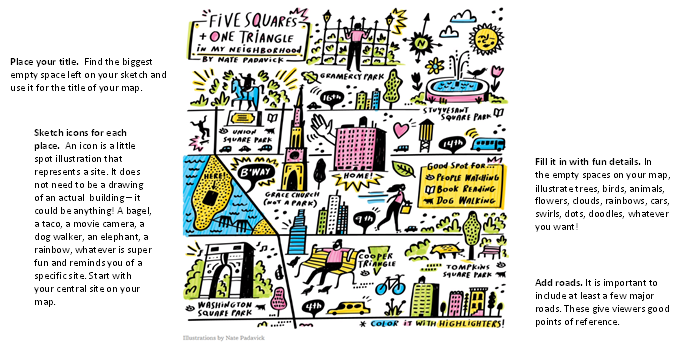
At the most fundamental level, COVID-19 has created a highly circumscribed geography in our daily lives manifested by social-distancing, stay at home orders, and long walks. Betsy Mason writes how social distancing has “shrunk everyone’s physical world into an extremely local space.” The City Lab invites readers to share hand-made maps of life under lockdown here. These mental maps have long been tools of geographers to map places infused with meaning, emotion, and cultural ties. How one conveys the world through sketch maps and drawings is unique to them, a reflection of personal experience. The New York Times invited people to “Make Your Own Illustrated Map”.
Through staying at home our virtual world expanded. Our social space includes video conference calls that provide an aperture into people’s houses with a view to bookshelves, artwork, and family photos. Alternatively, people are opting for background of places they have been – using pictures from past travels as a backdrop linking home and globe in yet another way (while hiding messy rooms).
Exploration of the home space is encouraged by the numerous sites that offer ideas about staycations that emulate the feeling of travel and have a geographic nuance. For example, sleep in a different part of your house. Set up a tent and camp outside. Take a different route for your daily walk. Explore your hometown. Time and space blend together to create a place for creative activities and home projects.
Complementing the exploration of the home space and local neighborhoods is an increasing interest in virtual travel. Multiple sites provide museum exhibits, art galleries, concert halls, and journeys to far-off lands through virtual reality experiences. What does travel mean in the age of COVID-19? You may visit places you never thought to consider – such as a virtual underwater tour of a 17th-Century Shipwreck or a trip to Mars. Here is a list of the best virtual travel tours. The world is literally at our fingertips, on our desktop, or in our laps.
A further reflection on place is in considerations of “where I work” leading to why do I live here? Newly remote workers (primarily white-collar workers) coupled with the enhancement of teleworking and virtual conference calling are leading some to ponder the need to be physically located near their offices – and opt to be closer to family or smaller cities. It will be worth tracking relocation across the United States as economies and states reopen.
In these unusual times, space and time have intersected in unfamiliar ways providing a period for reflection. The Great Pause or the Anthropause reveals the new geography of everyday life where adaptations are part of personal decisions about social distancing and self-isolation. However, this interval has shown the collective resiliency of the human spirit and the ability to connect across space and time through evening singing from China to Italy, beating pans in the London to New York, to howling in Colorado.
*The Geospatial Centroid Rapid Response Team is committed to:
- Helping to identify and examine emergent issues
- Illustrating the spatial nature of the most current challenges
- Elevating spatial thinking in science-based decision making
Geospatial Centroid Staff: Melinda Laituri, Sophia Linn, Dan Carver
Geospatial Centroid Interns: Arian Brazenwood, Luke Chamberlain, Caroline Norris